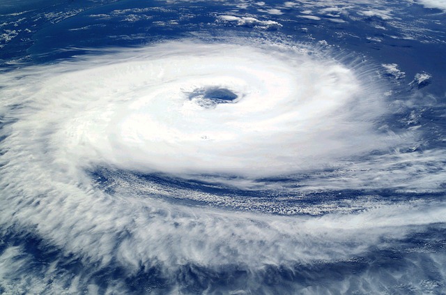
The cyclones in India have become more frequent and deadly in the current century. The warming of the Indian ocean is often said to be the primary cause. In this article, we will discuss what are cyclones, their formation, and some infamous cyclones that struck the Indian coasts in recent years.

A cyclone is a large storm system comprising high-speed winds and thunderstorm clouds that rotates around a low-pressure area known as the eye of the cyclone. These storms generally form in tropical zones and hence are sometimes called tropical cyclones. The cyclone rotates counterclockwise in Northern Hemisphere and clockwise in Southern Hemisphere. Cyclones that strike the Indian coast rotate in a counterclockwise direction.
A cyclone, hurricane, typhoon, willy willies, and tropical cyclone are all different names for the same kind of storm. In the Indian Ocean and South Pacific Ocean, these storms are known as cyclones. In North West Pacific countries, these storms are known as typhoons. In North Atlantic and Northeast Pacific countries, they are known as Hurricanes. In Western Australia, they are sometimes known as Willy Willies.
Formation of a cyclone
Things to learn before understanding cyclone formation-
1. Coriolis force

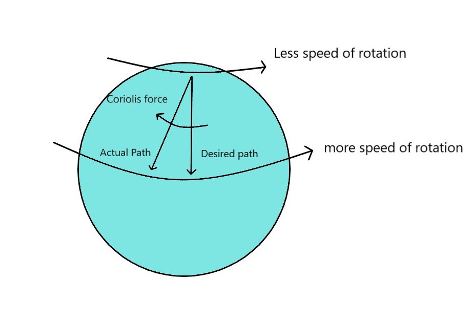
It is an inertial force that acts on objects moving up or down the latitudes in the Northern or Southern Hemisphere. As we know the Earth rotates at a faster speed at the equator and at a slower speed at the poles. If an object tries to move from the North pole towards the equator in a straight line without being attached to the ground, it will land right of the desired destination. Similarly, if an object tries to move from the equator towards the North Pole in a straight line without being attached to the ground, it will again land right of the desired destination.
2. Air movement based on pressure
Air or wind moves from a high-pressure area to a low-pressure area.
3. Air movement based on temperature
Warm air rises and cool air sinks.
Requirements for a cyclone formation
- Surface ocean water temperature of 26.5 degrees or more and the water must be at least 50 meters deep.
- The atmospheric temperature must dip sufficiently with height to support the formation of clouds.
- A preexisting low-level disturbance near the warm ocean water.
- The wind speeds must not change too much with height i.e. vertical wind shear must be less.
Formation
When the warm ocean water near the equator (above or at 26.5 degrees Celsius) evaporates, it makes the air above the water surface warm and moist. This warm, moist air then rises, creating a low-pressure area below it. As we know air moves from an area of high pressure to low pressure. Air from surrounding areas rushes towards the low-pressure area where it becomes warm and moist and consequently rises creating a cycle.
The air rushing in starts rotating because of the Coriolis force. The rising moist air cools as it gains elevation and hence clouds are formed. These winds and clouds together rotate giving rise to the cyclone. These cyclones are known to reach diameters above 300 km.
In the Northern Hemisphere, the cyclones rotate counterclockwise and in the Southern Hemisphere, they rotate clockwise. The eye is relatively calm. Higher pressure cool air moves down into the eye from above.
Cyclone Categories according to Indian Meteorological Department (IMD)
Super Cyclonic Storm: Maximum wind speeds of above or equal to 221 km/hr.
Extremely Severe Cyclonic Storm: Maximum wind speeds of 166-220 km/hr.
Very Severe Cyclonic Storm: Maximum wind speeds of 118–165 km/hr.
Severe Cyclonic Storm: Maximum wind speeds of 89–117 km/hr.
Cyclonic Storm: Maximum wind speeds of 63–88 km/hr.
Deep Depression: Maximum wind speeds of 51–62 km/hr.
Depression: Maximum wind speeds of 31–50 km/hr.
Landfall
When cyclones reach a coast, it is known as landfall. The wind speeds slow down upon landfall as there is no warm ocean water to fuel the cyclone. In general, cyclones die down when they make landfall or when they reach cold waters. Landfall can cause extreme damage to life and property. Below discussed are some of the most destructive cyclones in India in recent years.
Recent Infamous cyclones in India
Tauktae
Tauktae was an extremely severe cyclonic storm that originated in the Arabian sea in May 2021. The cyclone made landfall in Gujarat and caused large-scale destruction on the west coast of India. The maximum wind speed observed was as high as 220 km/ hr. The storm took the lives of over a hundred people and several went missing.
Amphan
Amphan was a super cyclonic storm that struck the east coast of India in May 2020. It was the most powerful tropical cyclone in recent history. The wind speed reached the 260 km/hr mark. The cyclone made landfall in West Bengal and claimed the lives of 128 people. It is one of the costliest cyclonic storms to even originate in the Indian Ocean.
Fani
Fani was also a super cyclonic storm with wind speeds reaching over 300 km/hr. The cyclone made its landfall in Orissa. It was formed on 26 April near the Indonesian island of Sumatra and dissipated on 5th May. A reporter 89 people lost their lives. The damage it cost was estimated to be over 1,00,000 crore INR.
Vardah
Vardah was a very severe cyclonic storm that affected the east coast of India, Andaman and Nicobar Islands, Thailand, and Indonesia. The cyclone made its landfall near Chennai and caused damage of over 25,000 crores INR. A reported 47 people lost their lives because of the disastrous storm.
Hudhud
Hudhud was an extremely severe cyclonic storm that originated in October 2014. It made its landfall near Vishakhapatnam, Andhra Pradesh. The maximum wind speeds observed were over 250 km/hr. The cyclone not only affect coastal areas but also caused widespread rainfalls in North Indian states as well as Nepal. The number of fatalities reported was 124.
Cyclones in India generally strike the East coast. Nowadays they have become frequent on the west coast as well. This is because the Arabian sea is one of the fastest-warming seas in the world, which favors cyclone formation.
Read more
hmmm🤔🤔🤔