
Canada and the United States share an international boundary that spans approximately 5,525 miles (8,891 kilometers), making it the world’s longest international border. Thirteen U.S. states share this boundary, which stretches from Alaska in the west to Maine in the east. These states are Alaska, Washington, Idaho, Montana, North Dakota, Minnesota, Michigan, Ohio, Pennsylvania, New York, Vermont, New Hampshire, and Maine.
On the Canadian side, eight provinces and territories share the international boundary with the United States: Yukon, British Columbia, Alberta, Saskatchewan, Manitoba, Ontario, Quebec, and New Brunswick.
Thirteen US States That Border Canada
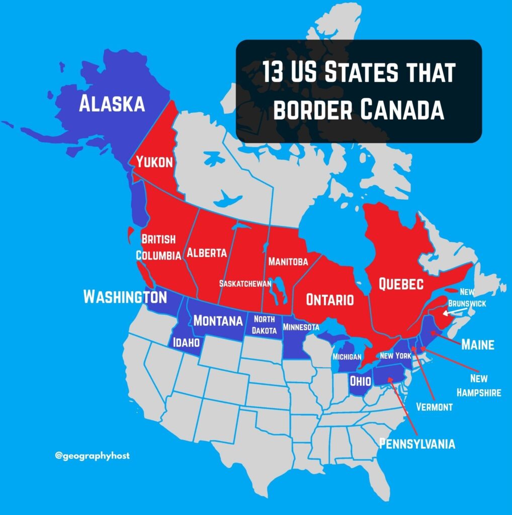
| State | Border length with Canada | Bordering Canadian province/territory | |
|---|---|---|---|
| 1 | Alaska | 1,538 miles (2,475 km) | Yukon |
| 2 | Washington | 427 miles (687 km) | British Columbia |
| 3 | Idaho | 45 miles (72 km) | British Columbia |
| 4 | Montana | 545 miles (877 km) | British Columbia, Alberta, and Saskatchewan |
| 5 | North Dakota | 310 miles (499 km) | Saskatchewan and Manitoba |
| 6 | Minnesota | 547 miles (880 km) | Manitoba and Ontario |
| 7 | Michigan | 721 miles (1,160 km) | Ontario |
| 8 | Ohio | 146 miles (235 km) | Ontario |
| 9 | Pennsylvania | 42 miles (68 km) | Ontario |
| 10 | New York | 445 miles (716 km) | Ontario and Quebec |
| 11 | Vermont | 90 miles (145 km) | Quebec |
| 12 | New Hampshire | 58 miles (93 km) | Quebec |
| 13 | Maine | 611 miles (983 km) | Quebec and New Brunswick |
Eight Canadian Provinces and Territories That Border The United States
| Province/Territory | Border length with the United States | Bordering US state | |
|---|---|---|---|
| 1 | Yukon | 752 miles (1,210 km) | Alaska |
| 2 | British Columbia | 1,347 miles (2,168 km) | Washington, Idaho, and Montana |
| 3 | Alberta | 185 miles (298 km) | Montana |
| 4 | Saskatchewan | 393 miles (632 km) | Montana and North Dakota |
| 5 | Manitoba | 309 miles (497 km) | North Dakota and Minnesota |
| 6 | Ontario | 1,715 miles (2,760 km) | Minnesota, Michigan, Ohio, Pennsylvania, and New York |
| 7 | Quebec | 505 miles (813 km) | New York, Vermont, New Hampshire, and Maine |
| 8 | New Brunswick | 319 miles (513 km) | Maine |
US-Canada Border Facts Table
| US-Canada border length | 5,525 miles (8,891 kilometers) |
| Boundary on land | 3,145 miles (5,061 km) |
| Boundary on water | 2,380 miles (3,830 km) |
| Number of US states bordering Canada | 13 |
| Number of Canadian provinces/territories bordering the United States | 8 |
(Also read: 4 US states that border Mexico)
Frequently Asked Questions
Which U.S. state has the longest border with Canada?
Alaska has the longest border with Canada by far, extending 1,538 miles. Among the contiguous 48 states, Michigan has the longest border with Canada at 721 miles, followed by Maine at 611 miles.
Which U.S. state has the shortest border with Canada?
Pennsylvania has the shortest border with Canada, extending approximately 42 miles along Lake Erie.
Which Canadian province/territory has the longest border with the United States?
Ontario has the longest border with the United States, stretching approximately 1,715 miles (2,760 km).
Why Is the 49th Parallel So Famous?
The 49th parallel forms a large portion of the US-Canada boundary between Lake of the Woods and the Strait of Georgia, stretching for approximately 1,260 miles.
Which U.S. states border Canada only over water?
Two U.S. states border Canada only over water: Ohio and Pennsylvania. Michigan’s border with Canada is predominantly a water boundary, but its complex boundary around islands makes its classification less straightforward. Some sources therefore include Michigan among the states that border Canada only over water, while others do not.
Read more