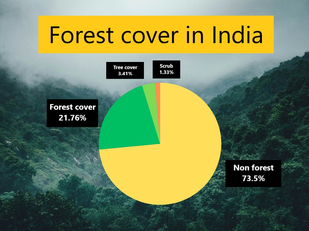
More than 1/5th of the landmass of India is covered in forests. As per the India state of forest report 2023, the total forest cover in India is 7,15,342.61 sq km, which is 21.76% of the total geographical area of the country. The forest cover is divided into 3 parts.
- Very dense forest: All land with tree canopy density of 70% and above.
- Moderately dense forest: All land with tree canopy density of 40% – 70%.
- Open forest: All land with tree canopy density of 10% – 40%.
| Forest type | Area | Percentage of India’s area |
|---|---|---|
| Very dense forest | 1,02,502.2 sq km | 3.12% |
| Moderately dense forest | 3,07,673.28 sq km | 9.36% |
| Open forest | 3,05,167.13 sq km | 9.28% |
| Total forest cover | 7,15,342.61 sq km | 21.76% |
(Note: The total forest and tree cover in India is 8,27,356.95 sq km i.e. 25.17% of the total geographical area.)
State-wise forest cover in India
| State/UT | Forest cover (sq km) | Geographical area (sq km) | Forest cover percentage (of geographical area) |
|---|---|---|---|
| Andhra Pradesh | 30,084.96 | 1,62,922.57 | 18.47% |
| Arunachal Pradesh | 65,881.57 | 83,743.22 | 78.67% |
| Assam | 28,313.55 | 78,438 | 36.1% |
| Bihar | 7,532.45 | 94,163 | 8% |
| Chhattisgarh | 55,811.75 | 1,35,192 | 41.28% |
| Goa | 2,265.72 | 3,702 | 61.2% |
| Gujarat | 15,016.64 | 1,96,244 | 7.65% |
| Haryana | 1,614.26 | 44,212 | 3.65% |
| Himachal Pradesh | 15,580.35 | 55,673 | 27.99% |
| Jharkhand | 23,765.78 | 79,716 | 29.81% |
| Karnataka | 39,254.27 | 1,91,791 | 20.47% |
| Kerala | 22,059.36 | 38,852 | 56.78% |
| Madhya Pradesh | 77,073.44 | 3,08,252.11 | 25% |
| Maharashtra | 50,858.53 | 3,07,713 | 16.53% |
| Manipur | 16,585.46 | 22,327 | 74.28% |
| Meghalaya | 16,966.84 | 22,429 | 75.65% |
| Mizoram | 17,990.46 | 21,081 | 85.34% |
| Nagaland | 12,222.47 | 16,579 | 73.72% |
| Odisha | 52,433.56 | 1,55,707 | 33.67% |
| Punjab | 1,846.09 | 50,362 | 3.67% |
| Rajasthan | 16,548.21 | 3,42,238.99 | 4.84% |
| Sikkim | 3,358.40 | 7,096 | 47.33% |
| Tamil Nadu | 26,450.22 | 1,30,060 | 20.34% |
| Telangana | 21,179.04 | 1,12,122.44 | 18.89% |
| Tripura | 7,584.77 | 10,486 | 72.33% |
| Uttar Pradesh | 15,045.80 | 2,40,927.56 | 6.24% |
| Uttarakhand | 24,303.83 | 53,483.36 | 45.44% |
| West Bengal | 16,832.33 | 88,752 | 18.97% |
| Andaman and Nicobar Islands | 6,732.92 | 8,249 | 81.62% |
| Chandigarh | 25 | 114 | 21.93% |
| Dadra and Nagar Haveli and Daman and Diu | 225.62 | 602 | 37.48% |
| Delhi | 195.28 | 1,483 | 13.17% |
| Jammu and Kashmir and Ladakh | 23,632.31 | 2,22,236 | 10.63% |
| Lakshadweep | 27.06 | 29.63 | 91.33% |
| Puducherry | 44.31 | 490 | 9.04% |
Top 5 states/UTs with largest forest cover area
- Madhya Pradesh: 77,073.44 sq km
- Arunachal Pradesh: 65,881.57 sq km
- Chhattisgarh: 55,811.75 sq km
- Odisha: 52,433.56 sq km
- Maharashtra: 50,858.53 sq km
Madhya Pradesh is the state with the largest forest cover area in India. The forest cover in Madhya Pradesh is 77,073.44 sq km.
(Also read: 10 major mountain ranges in India | subranges | destinations)
Top 5 states/UTs with the highest forest cover percentage (of their geographical area)
- Lakshadweep: 91.33%
- Mizoram: 85.34%
- Andaman and Nicobar Islands: 81.62%
- Arunachal Pradesh: 78.67%
- Meghalaya: 75.65%
The stats provided in this article are as per the latest India state of forest report.
Frequently Asked Questions
21.76%
7,15,342.61 square kilometers
Madhya Pradesh (77,073.44 sq km)
Lakshadweep (91.33%)
Lakshadweep (91.33%), Mizoram (85.34%), and Andaman and Nicobar Islands (81.62%)
Read more
This article is very useful. Nicely written and good representation.
Thank You!!
very informative post.
Thank You!!
Thank you very much
Detailed and well-written article! Thank you!!
Thank you
The whole article is very exhaustive because it is actually showing figures for diff States ,under different categories. My only concern is the authenticity and genuine ness of the Figures. I hope all the figures are, by & large, correct.
A job very well done.
Which year is this for? Comments for this article are from 2020!
The data in this post is based on State of forest Report 2021. I keep updating the data after every new report.
nice article
Thank You
Hello! I came across this article while researching for green cover statistics as apl part of my grade 10 project. I have managed to get temp and rainfall data from imd website, but am unable to get green cover data for Pune district. We wish to study the correlation.
Could you guide as to where can I find the green cover data for Pune district.
Regards.
The forest cover (2021 data) in Pune district is 10.97% (1,716.49 square kilometers).
It’s so good better then early years know a day improvement is so Better then other than country
Is it 2023′ report?
2021 report as of 19 August 2023.
Superb